Trekking in Ladakh with an All-Women Team
I’d just arrived in Ladakh, in the far north of India, and was planning on staying all summer. My white-water rafting guide partner had found work at a riverside camp, and I was left kicking around Leh on my own. I was itching to get out and see this amazing part of the country that I’d dreamed of visiting for so long, but although I was reasonably fit, I wasn’t up for a strenuous high-altitude trek.
Strolling the touristy streets of Leh, I was overwhelmed by all the travel agencies lining the streets. So, I walked into the office of the Ladakhi Women’s Travel Company and asked them what they thought I should do with three or four days. I wanted to go trekking in Ladakh, but where to begin?
Choosing a Route for Trekking in Ladakh
Generally in India, this tactic is not one I would recommend. Walking into a shop or agency and putting yourself at their mercy, you really will be at their mercy. But I had read good things about the Ladakhi Women’s Travel Company. As a solo female traveller wanting to go on a trek, I knew I would prefer to have a female guide, and the Ladakhi Women’s Travel Company only employs female guides and porters. (They do accept male clients, but only if there is a woman in the group).
They were very helpful and did not do any of the hard sell that I dread in India. They gave me two options of trekking itineraries I could do in three-four days. One easier one that took in a lot of monasteries and cultural sites, the Sham Trek, or a harder one that was more about the wildlife, expansive views and tiny villages, the Hemis National Park Trek.
I was torn. I really want to see the amazing monasteries of Ladakh. And the old Elen would have jumped at the choice of the ‘easier’ trek, which didn’t climb so high. But I realised that I hadn’t come all this way just to play it safe. So, much to the surprise of all of my family members who were tittering away inside my head, I signed up for the harder trek, and four-day trip that included ascending a 4900-metre pass. Just one other woman had signed up for this trek, so it would be a small and intimate group with just the two of us and our guide (I opted not to get a porter as I didn’t really need one).
Trekking in Ladakh with an All-Women Team
Day 1: Leh to Jingchen to Rumbak
My firecracker of a guide, 24-year-old Tsogyal, picked me up from my hotel at 8am, and we drove out of the city for about an hour. As a traveller in this part of the world, it is often difficult to get to know local women, as the service industry (including the tourism industry) is dominated by men. This, in fact, is one of the reasons why the Ladakhi Women’s Travel Company was established—to fill this gap, for the benefit of Ladakhi women who had previously been excluded from the guiding profession, as well as travellers to Ladakh. Before we’d even arrived at our starting point, Tsogyal and I had exchanged life stories, and I knew we were going to get along very well. I’ve had great male trekking guides before, but the greater sense of intimacy that a female traveller will get with a female guide is precious.
There are several phases I go through on multi-day trek. The first phase is ‘I don’t want to get out of the car’. The drive to Jingchen was so jaw-dropping—along the edge of Indus River Gorge—that I would have been happy doing a vehicle tour. But no, I had to walk.
Day one was short and simple. For the first 45 minutes or so we followed the dusty gravel road, and then diverged up rocky slopes, following small, cold streams that were clean enough to drink from. We climbed in elevation gently, and remained within enclosed valleys most of the time. Tsogyal told me at first that this day would be about 3-3.5 hours walking, and as I consider myself a slow trekker, I was banking on it being 4. But no, we made it to Rumbak in less than three hours. Tsogyal said we were moving quickly, which was the first time anyone has ever told me that, I think.
I had never been anywhere like this before…
The short day was so we could acclimatise. Leh is at around 3500 metres, and Rumbak is at 3870 m, but our destination on day two was 4100 m. Once you get above 3000 m it’s generally not a good idea to ascend more than 3-400 metres in one day. Many people I met along the way on this trek did, but some of them had headaches, found it difficult to sleep, had a much harder time breathing than I did, and walked at a much slower pace.
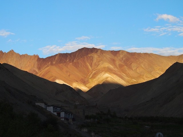
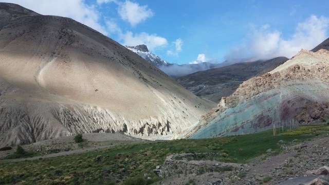
Although the landscape of Ladakh initially appears to be a monotone sandy brown in parts, a more ochre orangey brown in others, there is in fact a lot of variation in the hues of the landscape as you go deeper within the mountains. Many rocks have a faded magenta tone, and others a faded aqua green that matches the pale clean colour of the streams.
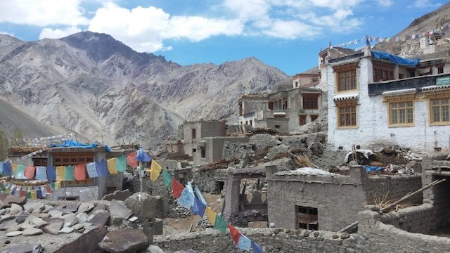
After settling into the homestay in Rumbak—more about that later—I went for a wander around the village. I had never been anywhere like this before, never imagined that these little villages of five or eight houses situated in the shade of huge rocky mountains, beside freezing glacial streams that are diverted to irrigate the farmland, even existed.
All the villages along the popular trekking routes here provide homestay accommodation for trekkers. Villagers with spare rooms open them up to travellers, and provide home-cooked food, too. There isn’t any kind of booking system—there’s barely phone signal here, certainly no internet connection—but they do operate on a rotation basis, so that every villager with a homestay gets some business.
Rumbak was silent, except for the occasional screeching donkey, and the whirr of the water pump, and the old woman singing as she dug her field. I was so glad of the silence, after months of brain-numbing honking in Kathmandu and then the cities of India.
Day 2: Rumbak to Yurutse, via the Stok La
Day Two was also a fairly leisurely day. We started with a detour up the valley in the opposite direction to where we would be walking later on. We approached the Stok La (pass), which I had the option of climbing, just for the fun of it, because we wouldn’t be crossing over to the other side. I declined. The trekking paths here are very hot, there’s barely any shade at all, and the sun is very strong at this altitude. But I can say that I sat at the base of the Stok La and looked up at the jagged, wafer-like pinnacle and thought it looked pretty cool.
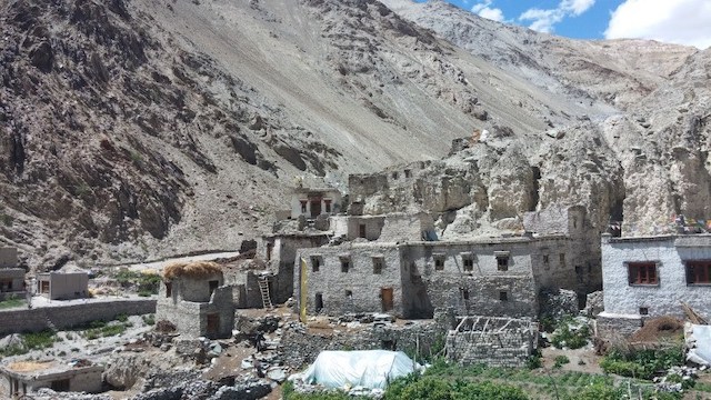
After lunch at the homestay, we continued on to Yurutse, barely two hours’ walk from Rumbak. Yurutse (4100 m) can’t even be called a town, as it’s a single home that opens itself up for trekkers during the season. I actually thought it was a monastery as we approached, and was delighted to learn that it was where we’d be staying. However, it was pretty basic and not very clean, certainly not as tidy as the homestay in Rumbak.
The mountainous landscape is largely barren, or close to it, with just small shrubs sprouting here and there. But around every settlement—even a one-house settlement like Yurutse—the ground is a vibrant green. The villagers divert water from the glacial streams up to their land so that they can grow crops—spinach, carrots, potatoes, turnips. But only in summer. The winter here is too harsh for anything to grow.
Day 3: Yurutse to Shingo, via the Ganda La
Today was the big day where we had to cross the Ganda La (pass), 4850 metres high. As there had been only one homestay in Yurutse, I met a lot of other trekkers the night before, and almost everyone set off at the same time. Groups quickly formed, though, as some people steamed ahead and powered over the pass with little apparent effort, and others trudged behind. I was somewhat of a trudger, but fell somewhere in the middle of the pack (not that it’s a race!)
It took about four hours from Yurutse to reach the top of the pass. The path itself wasn’t all that difficult, as it wasn’t very steep. But ascending around 700 metres at that altitude had dramatic effects on the oxygen levels in the air. So while my legs felt entirely strong enough to carry me up the mountain, it got to the point where the air was so thin that I was gasping and needing to stop to catch my breath every five steps.
A freezing cold wind whipped over the pass at the top, but we sat in the shelter of a small stupa and ate our packed lunches. The weather was perfectly clear, so in the direction we had come from we could see the Karakoram Range in the distance, and in the other direction the Zanskar Range.
I was walking with an American guy who had only arrived in Leh a couple of days before and wished he’d had a bit more acclimatisation time before starting the trek. Behind us were a Belgian couple who were really struggling. The guy was suffering from the thin air, and taking it very slowly, and the woman was wearing some of the most inappropriate clothing for a mountain trek I have ever seen.
Behind us were a Belgian couple who were really struggling.
She looked very stylish in her camel-coloured capri pants and matching boat shoes, but she had developed painful blisters all along the front of her toes, making the downhill trek that was to come close to impossible (she actually ended up taking off her shoes and doing it barefooted, which would have been disastrous had she cut the bottom of her feet).
I kept reminding myself not to feel too excited about the descent from the pass, because descents can often be more painful than ascents—there’s so much pressure put on the knees that you can end up with really wobbly legs. But this time, because the air became noticeably richer with oxygen almost immediately, the descent was great. The Zanskar Range lay ahead, although it ducked out of view the lower we got.
It took about two hours to reach the tiny village of Shingo (4150 m), with just two homestays. The homestay here was particularly lovely, with colourful bedspreads and bright rooms with views of the amazing village and gardens. The village was practically carved into the cliff, and like elsewhere, the gardens were a fertile green.
Day 4: Shingo to Chilling
Most other trekkers we had met were continuing on for the longer Markha Valley trek, which is very popular and meant to be spectacular, but takes at least eight days. They went in one direction, and we went in another. But what a direction it was! We walked into a steep red canyon; I’ve never been to Arizona or Western Australia, but they are the only points of comparison I can think of to describe this landscape.
We passed through the little town of Skiu, with a small monastery perched on a hill (aren’t they always perched on a hill around here?!), and stopped for tea in a couple of places, including Tsogyal’s aunt and sister’s houses. She is from the village of Markha, in the Markha Valley, so knows this region intimately.
Most of the day’s five-hour walk was a gentle descent, with just a couple of steeper parts as we neared the Zanskar River. It was at this point that we really felt grateful for the presence of a guide, as it would have been difficult to find the right path without one. In general, if you are an experienced trekker and aren’t alone, the Markha Valley and Hemis National Park region wouldn’t be a bad place to trek independently. The paths are mostly quite obvious, and there seems to be a steady stream of other trekkers. But there are patches, like the final descent to the Zanskar River, that could be confusing if you were on your own.
Once we got to the river, we had to cross it, but there was no bridge—we were going by trolley!
Once we got to the river, we had to cross it, but there was no bridge—we were going by trolley! I’d seen these things in Nepal, but never considered that I’d be riding in one over a raging grey river. A trolley in this part of the world is a little wooden basket on a wire (a thick wire!) suspended over the river. For the first part you glide, but once you reach the middle you have to pull yourself the rest of the way, or be pulled if there’s someone helpful on the other side. Amazingly, Tsogyal, my trekking companion and I all fit into the trolley at once—with packs—and made it over in one piece.
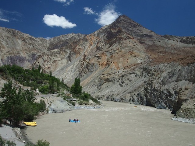
On the other side, our taxi back to Leh was waiting for us, a 2-3 hour drive away. The drive took us along the road above the Zanskar River, and we even followed some rafters after their put-in at Chilling. The road here was still being built, or surfaced, and there were some very hairy patches. I was sitting on the side of the vehicle nearest the petrifying cliff drops. Luckily the roads did improve after a while, and I could enjoy the extraordinary canyon and mountain views without fear.
Tips
Best time to visit Ladakh: June to early September. The peak trekking season is July and August, where homestays and campsites can get very full, and the trekking agencies are at their busiest.
Because this is summer trekking, you shouldn’t expect very cold temperatures, even at night, although layers and a down coat are a good idea. Even at 4100 metres, the highest I slept, I didn’t need my woolly hat or gloves at night.
This post originally appeared on www.elenturner.com
Elen Turner is a travel writer and editor based in the South Island of New Zealand. Her writing on New Zealand, Nepal, and India has appeared in a variety of places, including The Best Women’s Travel Writing Vol. 11, Lonely Planet, Architectural Digest, TripSavvy, The New Zealand Herald, and more. She is a developmental editor, copyeditor and proofreader who specialises in helping women authors express themselves through non-fiction and fiction.
Instagram
Facebook
Related Posts
 A 24 Hour Stopover In Budapest, Hungary
 Leaving a Life of Walmart and Reruns to Teach in Hong Kong
 Relocating for a Job: From Madagascar to Silicon Valley
 Adventures In Breastfeeding Around The World
 7 Important Things to Know Before Traveling to Greece
 The Red Light District in Brussels
 Italian Men: The Unofficial Guide
 Studying Abroad 30 Years After College
One thought on “Trekking in Ladakh with an All-Women Team”